
Filey's 'Roman' Jetty
Bathymetric survey produces stunning new images

In recent years the discovery of a substantial Roman villa at Eastfield near Scarborough has prompted a reevaluation of the Roman presence on England’s north east coast. Thus when a recent bathymetric survey by the North East Coast Observatory of the inshore waters produced stunning images of Filey’s ‘Roman’ jetty, it seemed like an opportune moment to look afresh at the fabled jetty and the current theories as regards it origins.
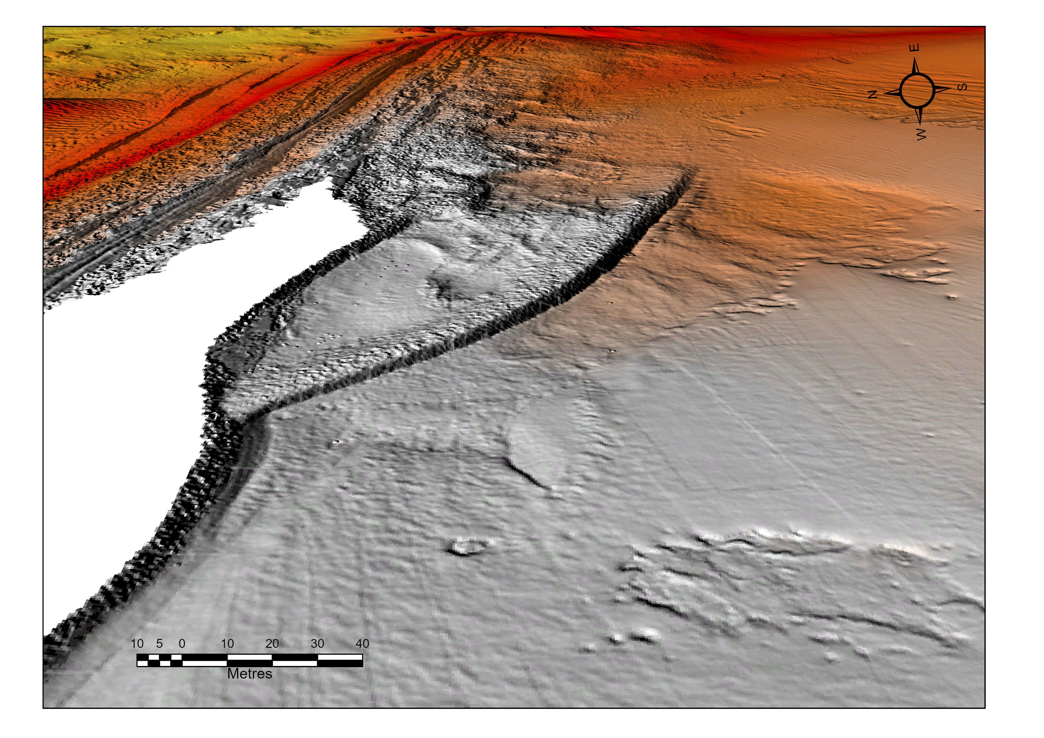
The ‘Roman’ jetty is clearly visible on the Bathymetric survey scan. Image courtesy of Dan Normandale using data from North Eastern Coastal Observatory.
The seaside resort of Filey is situated on the Yorkshire coast, 7½ miles south of Scarborough and 10½ miles north of Bridlington. Its situation overlooking the North Sea and the huge sweep of Filey Bay has been attracting visitors since at least the 1600s. The Bay is framed to the north by Filey Brigg, an important geological, historical and ornithological site, and to the south by the high chalk cliffs of Speeton and Bempton that lead ultimately to Flamborough Head. In between lies miles of golden sands which for generations have been a magnet for holidaymakers.
However, Filey and its bay has a history that stretches back far beyond modern holidaymaking trends. There was a Roman signal station on the headland of Carr Naze. It was the southern-most signal station of five along the Yorkshire coast: the others being Huntcliff near Saltburn; Goldsborough, near Whitby; Ravenscar; and Castle Hill at Scarborough. The Filey station was in use from roughly 375-410 AD. There was a beacon on top of a tower, which would be lit if enemy ships were seen approaching.
Landslips have provided evidence of the station, but also threaten to wipe it from the map. Indeed, the signal station was rediscovered in November 1857 after a landslip had revealed the site. An archaeological investigation followed and five stones recovered today stand in the Crescent Gardens. One of the stones has a depiction of what appears to be a hound chasing a stag. The site of the signal station has been further investigated by digs in 1927 and in 1993-4. Quite a number of artefacts were found, including bronze coins, pottery and animal bones. The highlight of the finds was a three foot high bronze statue of the god Mercury, it can be viewed in the Rotunda Museum at Scarborough. Today there is an explanatory board telling the story of the signal station.
The remains of the Roman Signal Station, today displayed in the Crescent Gardens, Filey
Among the rocks beneath the site of the signal station is, what has been claimed to be, a Roman jetty. It emerges during the Spring Tides and it has been the subject of intense discussions for well over a century. The ‘jetty’ is best viewed from the top of Carr Naze, it points towards Bempton Cliffs, its angle being quite distinct from the Brigg itself.
The ‘Burleigh’ chart of c 1560, A Plotte made for the discripcion of the River of Humber and of the Sea and Seacoost from Hull to Skarburgh in the Reigne of Queene Elizabeth, appears to show a quay of sorts. Joan Blaeu in his Sea Mirror, published in 1625 stated: 'Without the head of Filey lieth a rock underwater called Filey Bridge, betwixt it and the pier, you may safely lie afloat with a ship of 100 lasts in 5 fathoms at low water’. These descriptions led Historic England to conclude that the jetty rocks ‘represent a harbour can now be in little doubt’.
As far back as 1828 in his book The History and Antiquities of Filey in the County of York, John Cole claimed that the jetty had been constructed at ‘some very remote period’. As the presence of the Roman signal station on Carr Naze was well-known, the assumption that it was a Roman jetty gained significant traction. However, in March 1922 Frank Gerald Simpson of the Yorkshire Roman Antiquities Committee and Thomas Sheppard of Hull Museum examined the site and concluded that the structure is a ‘cranch’, an accumulation of boulders built up by the actions of the tide. That did not dissuade the Yorkshire Federation of Sub-Aqua Clubs deploying no less than sixty divers in search of the jetty’s Roman origins in June 1972. Unfortunately no definite conclusions were arrived at.
In his peerless 1990 book, Filey, from fishing village to Edwardian resort, Michael Fearon wrote that the jetty ‘could hardly be pre-Roman’ and noted that the Anglo-Saxons rarely used stone for such constructions. He concluded that if it was indeed man made, then the most likely people to have constructed it would have been the Romans. The recent bathymetric survey does not prove or disprove the Roman link, but it does appear to reinforce the theory that it was man made.
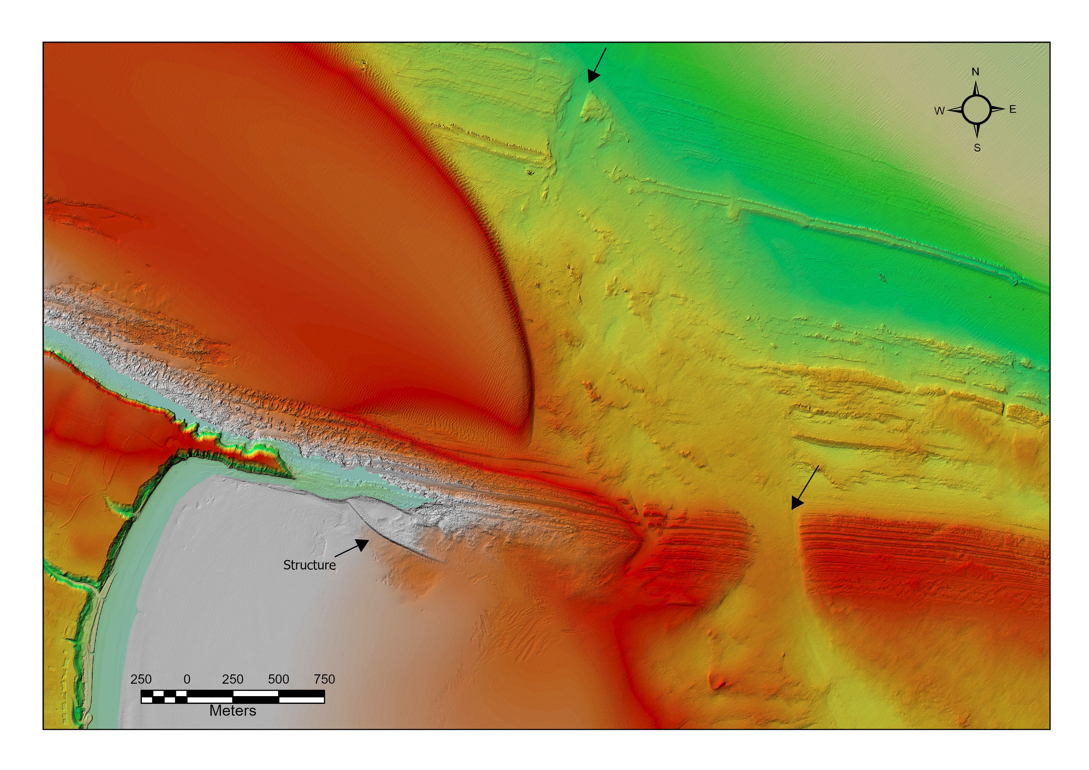
An overview of Filey Brigg and the ‘Roman’ jetty from a bathymetric survey. Image courtesy of Channel Coastal Observatory.
In 1997 Historic England surveyed the location and concluded that it was a probable medieval breakwater or pier associated with quarrying. A diving survey by Filey Brigg Research Group suggest that a timber framed jetty may have been in use, to facilitate the removal of stone from quarrying around Carr Naze and the Brigg. A detailed account can be consulted on the Historic England website. Some excellent images and further commentary is offered by the Crimlisk Fisher Archive at Filey.
The large amount of quarrying undertaken on Filey Brigg since medieval times seems to be the most likely explanation for the construction of a jetty. Its location well towards the seaward end of Carr Naze, appears to suggest that it was not sited to serve the village of Filey, but to facilitate the dispatch of quarried stone from the Brigg. The limited evidence available does lean towards the theory that Filey’s ‘Roman’ Jetty was not connected to the Roman Signal Station, but was constructed to serve a medieval stone quarry.